
To begin, know this: I love maps. To me, a well-done map is the pinnacle of functional graphic design. I say I like geography but I think I’m just decent at it because I like staring at maps. I say this without reservation: one of the best features of the internet is the advent of the zoom-able/scroll-able (and now 3D rotate-able) map. As an aside, it’s a move of pure advertising genius that businesses become visible upon reaching a certain zoom level on a map (and the more you pay, that higher up you will show). Nice one, Google.
Scrolling the earth and zooming in on regions is one of my favorite things to do. GoogleEarth changed the game, as did StreetView, but those are separate conversations. For today, simple road maps will do. One of the first things that struck me and continues to intrigue me is all the things you can tell about a region from seeing multiple level views of a road map. Travel has always been a keen indicator of the advancement of society. Yet despite innovations in air travel, train travel and all mass transit, around the globe, automobile travel still rules. Countries, as viewed on a map, are a web of highways and freeways with an accurate tell of urbanization: the more roads, the more people.
One interesting way to quickly find a large city on a map without even looking at the names is the presence of ring roads. A ring road is like it sounds – a road (or series of connected roads) that circles back to meet itself. Also known as a beltway, beltline or a circumferential or orbital highway, ring roads provide a fascinating study on the definition of a city boundary. You get an easy, clear visual of a city’s presence compared to the surrounding landscape.
While a true city boundary is jagged and sprawling and often changing, a city’s ring road is a much more permanent, poetic and beautiful border.
Its lines flow and curve to parallel a river or encompass a neighborhood. It bends to avoid splitting a historic district or skirt a geographic feature. There is information in every angle. Every subtle weave and bend of the ring means something.
As our world becomes ever more complicated, with near infinite ways to compile and interpret data, I find comfort in discovering simple ways to slice life. Ring roads, as a visual of a city, are a simple slice. They are a link to a city’s past and can be a window into its future.
Beijing is a perfect example of this dual purpose. Its first ring road, starting in the 1920’s, was formed by tram lines that circled the city’s core. In the ’50’s the trams were removed and wider automobile ring roads were added. Even though the original ring was taken over by crossing streets, today’s innermost ring road is still called the “2nd Ring Road”. Beijing keeps adding rings in concentric fashion and even has plans for a“7th Ring Road” as an expressway outside this enormous city. It’s true: No one rings like Beijing.
Many innermost ring roads give a visual reminder of the long history of its city. In Vienna, for example, the Ringstraße encircles Old Town. The street lies where protective city walls once stood that were surrounded by a 500-meter wide protective berm or glacis. 500 meters! You can probably guess everything worth protecting in Vienna in the 13th century was inside. At the ringstraße’s perfect center stands St. Stephen’s Cathedral (Stephansdom), consecrated in 1147 and built on the ruins of two earlier churches. Further fortifications were built in the 17th century and a new, wider city wall was established. This border too still exists as the Gürtel ring road and provides a clear line between Vienna’s inner and outer districts.
In fact, if you want to find the most historic parts of many an old city, try finding its innermost ring. Case in point: the mathematical center of Moscow’s inner ring road? …Red Square.
Some ring roads serve as a traffic bypass, a faster way to the other side of the city without having to drive right through it (like you do in downtown Seattle). It becomes a necessary traffic management tool of the Urban Planner.
Many cities have both types of rings, like London and Rome. The city’s inner ring architecture surrounding its historic core has informed the city’s growth (in semi-pie-shaped districts) outward, right up to an outer ring bypass highway. The circular nature of the boundary means these cities growth can’t be tracked in any kind of nice grid.
A ring road, though, is not necessarily a good indicator of city’s size, as some cities sprawl far beyond their ring roads. Case in point, New Delhi. Dense Parisian suburbs, likewise, have sprawled well beyond its ring but nevertheless, Paris is an example of a near-perfect ring road delineation. Its 20 arrondissements (city districts) are neatly contained inside the Boulevard Périphérique, starting with Arr. number 1 in the center and spiraling out clockwise from there. The official city boundary, over time, has jutted out of the circle at a couple spots but the delineation holds true. Property values (well, at least according to an episode of House Hunters International I saw once) clearly follow this path – the most expensive rates are in the inner districts (Le Marais), and spiral outward (downward in price) from there, dropping sharply outside the ring.
Many cities have partial ring roads – ‘U’s and ‘C’s that still serve the same purpose of providing faster travel around a city center and delineating districts. Berlin’s A100 road, for example, curves around the city core in a sort of C shape and was intended as a complete ring road but was never completed. Yet locals still call it the Stadtring (City Ring).
In short, I find ring roads a compelling and unique way to identify a city. And when broken down to basic forms provides us a new visual language. That poetic and beautiful border can function as more than just a road. Each one is so unique and personal to the city, it may be to time to step out into something more.
Can you spot any cities from this ring road grid? (answers below)

RING NOTES
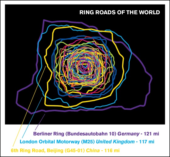
The above visual shows all these cities’ ring roads laid together (at close to accurate scale) making for a fairly dizzying image.
•Berlin’s Berliner Ring is the longest ring road, at 121 miles, just ahead of London’s M25 Orbital Roadway. Houston, however, has already begun construction on a proposed 170 mile loop highway, aptly named The Grand Parkway.
•The Minsk Beltway (Belarus) is a great example of a city border contained inside a highway. No highways go within; they all stop the ring. Does life slow down inside the ring as well?
•Bucharest’s Centura București wins the award for most perfect circular ring. Its diameter is between 13 and 14 miles nearly any direction you measure.
•Beijing is the best ringer, featuring no fewer than 5 ring roads – concentric circles that resemble a toddler-drawn bullseye.
•Washington DC’s ring road, the Capital Beltway, uses “Inner Loop” and “Outer Loop” for naming directions of travel on the same road, since compass directions don’t work when you can travel both directions of a circle. Think about that – you can travel North, South, East and West continuing on the same road.
London cleverly puts their rings to work: their inner ring is an automobile parking tax boundary.
Madrid has a fantastically huge network of circling highways and crossing arterials that resemble a great curvy spider web. It’s ring road chaos!
The Indianapolis Interstate 465 ring highway is the start of many off-shooting highways, drawing comparisons to a pencil-drawn sunshine or a spider, depending on your perspective. Hmm, could that tell you something about the viewer? Can we call this Indy’s Roscharch test?
Ring Road city answers:

